
History, risks and geohazard awareness
The deadly landslide that swept through Lions Bay on December 14 not only took the lives of two long-term residents, but raised many questions about life in Lions Bay.
Since that day, Watershed readers have shared many of their questions with us. What could cause such a catastrophic event? Was this a natural or man-made disaster? Do other potential geohazards exist in and around the Village? Who is ultimately responsible for geohazard monitoring? What role does climate play?
Concern levels are high in the Village, and a second round of drop-in counselling is being made available to the community on the afternoon of January 26.
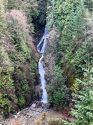
Possible causes of the Battani Creek landslide remain under investigation, and the Village continues under a state of local emergency, which, according to CAO Ross Blackwell, was extended today until February 6 at least.

Living in a region where the seismic hazard is identified at the top of the scale (as seen on this map provided by Natural Resources Canada) means that the identification and mitigation of geohazards needs to be top of mind.
Today, The Watershed begins a closer examination of some of these bigger-picture questions that have arisen with regard to the safety and security of life in and around Lions Bay.
In this series, we'll review the history of geohazard incidents along the Sea to Sky Corridor, take a look at ongoing issues that remain unresolved and review at any mitigating action that has already been taken by local or provincial government.
We will try to understand where responsibility lies within levels of government, and the state of current legislation on the complicated issues of geohazard mitigation in the province. We'll also talk to experts who have long-standing concerns with the status quo, take a look at what action local home-owners can take and try to anticipate what might come next.
This is the first in a series of articles with the goal of increasing geohazard awareness
in the Sea to Sky region. We value your opinion! Share your thoughts below,
or email editor@lionsbaywatershed.ca
Please consider supporting local independent journalism
by subscribing HERE.
Comments